

As of Jan. 24, 2025, all 50 states, the District of Columbia, and five territories including American Samoa, Guam, Northern Mariana Islands*, Puerto Rico, and U.S. Virgin Islands have approved mitigation plans.
A total of over 21,579 local governments and 193 tribal governments have approved or approvable-pending-adoption mitigation plans.
The nation's population who live in communities with current mitigation plans is nearly 80.5%. States, tribes, territories, and local governments benefit from all hazard planning because it helps them understand natural hazards and develop mitigation strategies. It also provides eligibility for certain non-emergency FEMA grants.
National Status Map
The national status map shows local jurisdictions with approved plans (light blue), approvable-pending-adoption plans (medium blue), and expired plans (yellow).
View an interactive version of the map to search the plan status for state, local, tribal and territorial governments. The data in this interactive tool are updated daily.
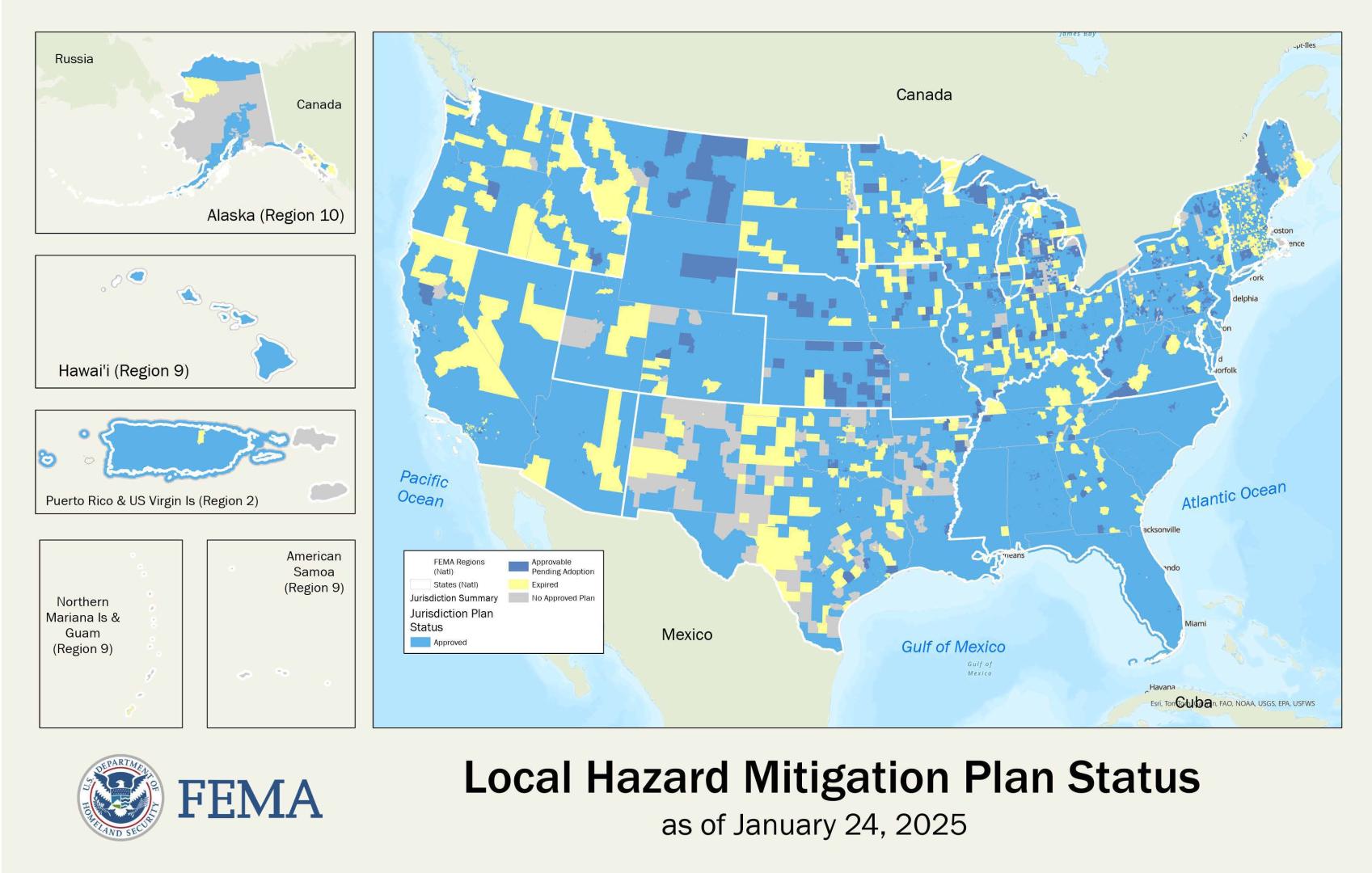
The information that supports the Local Hazard Mitigation Plan Status map is publicly available from the OpenFEMA website. This dataset is a spreadsheet containing essential statistics to document hazard mitigation plans for the nation, including plan titles, plan owners, critical statuses and dates and the number of people that a plan covers.
If you notice any data discrepancies, or identify any issues with this mapping service, please contact FEMA-RiskMAP-ITHelp@fema.dhs.gov.
FEMA does not maintain copies of plans only the plan status. To look at a copy of a state, local, or tribal mitigation plan, contact the respective government directly.
This product does not contain Personally Identifiable Information (PII).
Enhanced State Mitigation Plans
As of Jan 24, 2025, 16 states earned FEMA approval for their enhanced state mitigation plan. These states are now eligible to receive more funds under the Hazard Mitigation Grant Program following a disaster declaration.
To receive approval of an enhanced plan, a state must show that it has developed a comprehensive mitigation program and is capable of managing increased funding for its mitigation goals.
Links below take you to state webpages to learn more about state hazard mitigation programs, plans and additional resources. Plan expiration year in parentheses.
States with Enhanced Mitigation Plans
Local Plan Approval Delegation Using Program Administration by State Authority
The Sandy Recovery Improvement Act of 2013 amended the Robert T. Stafford Disaster Relief and Emergency Assistance Act and provided FEMA with authority to carry out provisions of the Program Administration by States (PAS) as a pilot program, including the delegation to approve local mitigation plans.
In 2023 FEMA released an updated program Hazard Mitigation Assistance Program and Policy Guide (HMA Guide).
The updated HMA Guide replaces the prior HMA guidance, including the 2015 Hazard Mitigation Assistance Guidance and Addendums (specifically, the April 1, 2013 and October 2017 PAS Pilot addendums). The HMA Guide provides helpful information for states, and tribal governments that choose to request for a Program Administration by States (PAS) delegation. More information on state, tribal or territorial PAS requests for local plan approval delegation can be found in Part 14. Program Administration by States (pdf. Pg.541-565).
As of Jan. 24, 2025, states that have received the delegation to approve local mitigation plans include:
- Florida
- North Dakota
- Ohio
- Vermont
- Wisconsin
Have questions or need technical support? Email our Mapping Information Platform Help Desk.
* In 2008, the Marshall Islands (RMI) and the Federated States of Micronesia (FSM) came under the jurisdiction of a compact agreement between FEMA and the United States Agency for International Development (USAID), therefore the State mitigation plan requirement is optional for these territories.
** Data users can get direct access to a geospatial information system (GIS) mapping service through Esri applications such as ArcGIS Online. Users can also get access through the Open Geospatial Consortium (OGC) Web Mapping Service (WMS) HTTP interface to request geo-registered map images. Information on how to access these mapping services is available from the Mitigation Planning Portal GIS Mapping Service Quick Start Guide Fact Sheet. The Quick Start Guide also includes a complete list of available spatial and tabular data as well as layer hierarchy.