

The Community Engagement Prioritization Tool (CEP-Tool or CEPT) enables the annual prioritization and selection of communities with which FEMA and state floodplain managers will engage to provide technical assistance, training, outreach, and National Flood Insurance Program (NFIP) compliance audits.
The CEP-Tool, an interactive mapping application, leverages analytic techniques to combine and transform data from various sources, such as OpenFEMA, FEMA’s Community Information System (CIS), Census, and the Centers for Disease Control (CDC), to better understand a community’s potential for floodplain management compliance.
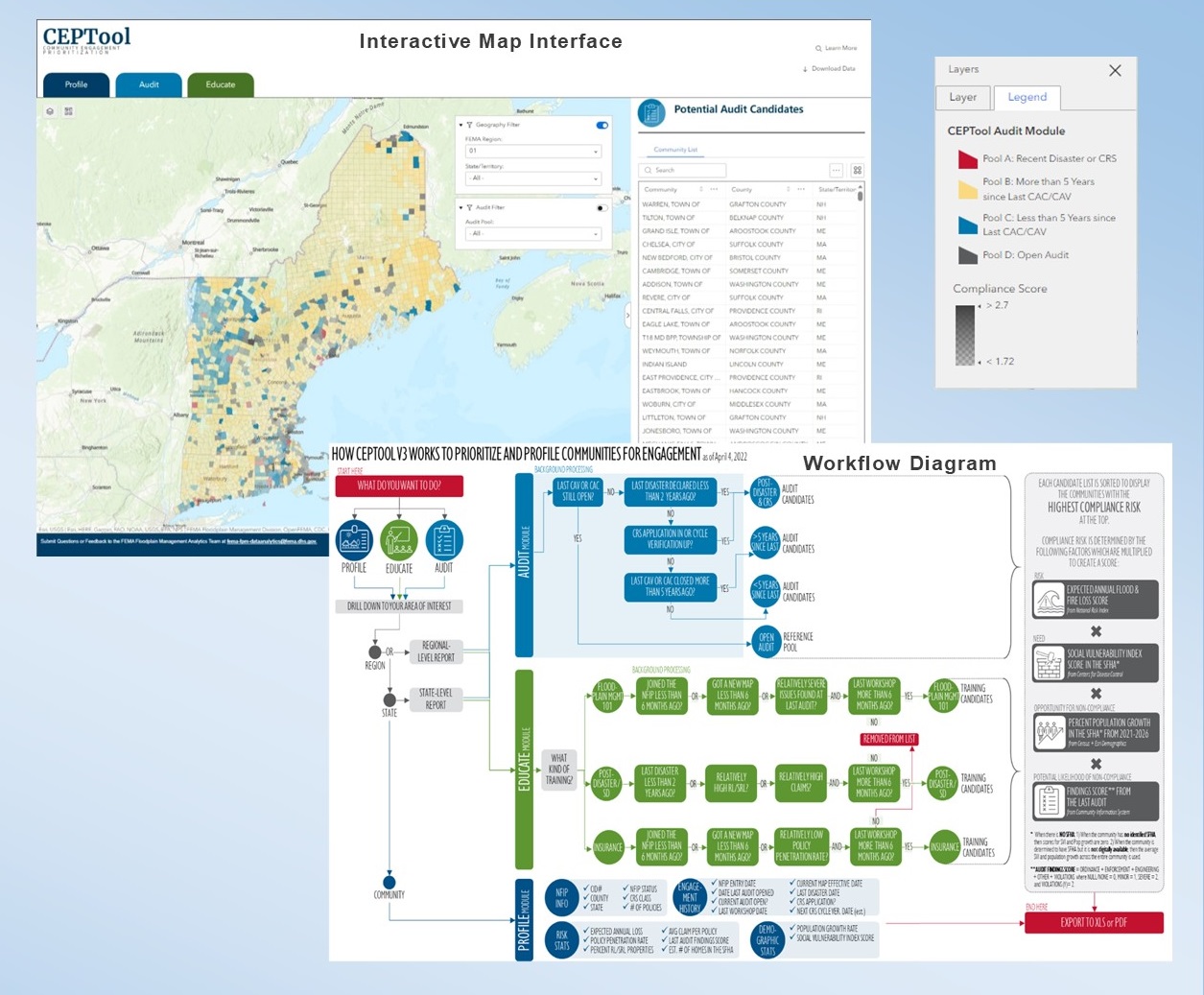
Community Engagement Prioritization Tool (CEPTool)
This video introduces the latest version of the Community Engagement Prioritization Tool (CEPTool), a geospatially enabled tool designed to help floodplain managers to characterize, prioritize, and select which communities to engage on compliance and education. This video provides users with a tour of the CEPTool’s three modules, instructions on using its various functions, as well as an overview of its community prioritization approach.
For more information or to request access, reach out to the FEMA Floodplain Management Division’s data analytics team.
Features and Capabilities
The tool harnesses geo-spatial analytics through the power of Geographic Information Systems (GIS) to orient users to insightful NFIP community summary information available to aid in their engagement and prioritization planning, including:
- Redesign and intuitive map interface;
- New Compliance Risk Score and Methodology;
- New module approach and logic flow for community prioritization & engagement (Profile, Audit and Educate);
- Update jurisdiction boundary dataset;
- New functionalities to interactively query, export (CSV, JSON, GeoJSON) and sort data;
- Optimize data access and transformation automation process (Python) delivering weekly CEP-Tool analytic data updates.
The latest version of the CEPT when used with other floodplain management related information supports answering these following questions:
- Is this a post-disaster community?
- What is the community’s history of mitigating high-risk properties?
- Is there an opportunity to turnover building stock in this community?
- Has the community demonstrated or expressed they are interested in better managing flood risk?
- What is the professional capability/capacity of the local government?
- Does the community need assistance after receiving a new Flood Insurance Rate Map (FIRM)?
- Are there significant gap areas within a state or FEMA Region which need greater attention?
Terms of Use
By using the CEP Tool, the user acknowledges that this data is presented "as-is" and is subject to change at any time. The data presented within the CEP Tool is updated weekly and is based on the best available information. The user also acknowledges that while the provided data is drawn from authoritative sources, there are fields that transform these data to offer the best possible understanding of flood risk (e.g., SFHA-specific estimates of social vulnerability or population growth). These calculations are completed at the national scale and may be less accurate than community-specific data. Review the Data Dictionary for explanation of attributes and derived field descriptions.
Notice from FEMA's Office of Chief Counsel:
THESE MATERIALS ARE PROVIDED "AS IS" WITHOUT WARRANTY OF ANY KIND, EITHER EXPRESS OR IMPLIED, INCLUDING BUT NOT LIMITED TO, THE IMPLIED WARRANTIES OF MERCHANTABILITY OR FITNESS FOR A PARTICULAR PURPOSE. USE OF THESE MATERIALS CONSTITUTES ACCEPTANCE OF THIS DISCLAIMER OF LIABILITY.
The authors of this software have used their best efforts in its preparation. These efforts include the development, research, and testing of the theories and programs to determine their effectiveness. HOWEVER, neither the authors nor the U.S. Government, nor any agency thereof, nor any of their employees, nor any of their contractors, subcontractors, or their employees, make any warranty express or implied, or assume any legal liability or responsibility for the accuracy, completeness, or usefulness of any information apparatus, algorithm, product, or process disclosed, or represent that its use would not infringe on privately owned rights.
Contact Us
To request access, training, and additional information about the CEP-Tool, please email the FEMA Floodplain Management Division Analytics Team. Access is available to authorized users, such as state floodplain mangers, NFIP state coordinators, and their staff. Additionally, access may be extended to approved local floodplain administrators, NGOs, and educational institutions.
If you are a State National Flood Insurance Program Coordinator, please reach out to your FEMA Regional Office or the FEMA Headquarters CAP-SSSE Coordinator with questions.
Learn more about the Community Assistance Program.