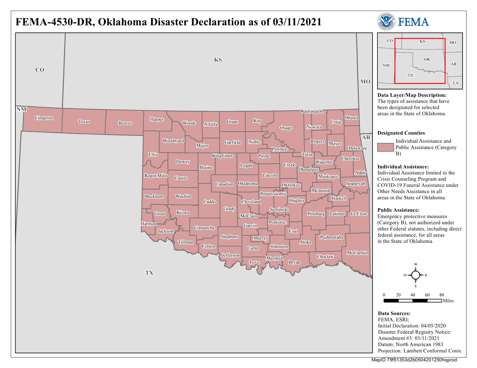
Áreas designadas: Desastre 4530
- English
- Español
Más sobre este desastre

Asistencia individual
Las personas y familias en estas áreas designadas son elegibles para servicios financieros y directos. Solicitar asistencia, o vea más información sobre el programa de Asistencia Individual.
- Beaver (County)
- Beckham (County)
- Blaine (County)
- Bryan (County)
- Caddo (County)
- Caddo-Wichita-Delaware (OTSA)
- Cherokee (OTSA)
- Chickasaw (OTSA)
- Choctaw
- Cimarron (County)
- Cleveland (County)
- Coal (County)
- Craig (County)
- Creek-Seminole Joint Area (OTSA)
- Ellis (County)
- Garfield (County)
- Garvin (County)
- Grant (County)
- Greer (County)
- Harmon (County)
- Hughes (County)
- Iowa (OTSA)
- Jackson (County)
- Jefferson (County)
- Kaw (OTSA)
- Kingfisher (County)
- Kiowa (County)
- Kiowa-Comanche-Apache-Fort Sill Apache (OTSA)
- Kiowa-Comanche-Apache-Fort Sill Apache-Caddo-Wichita
- Lincoln (County)
- Logan (County)
- Major (County)
- McCurtain (County)
- McIntosh (County)
- Modoc (OTSA)
- Murray (County)
- Nowata (County)
- Okfuskee (County)
- Okmulgee (County)
- Osage Indian Reservation
- Otoe-Missouria (OTSA)
- Ottawa (County)
- Ottowa (OTSA)
- Pawnee (County)
- Peoria (OTSA)
- Pittsburg (County)
- Pontotoc (County)
- Pottawatomie (County)
- Quapaw (OTSA)
- Roger Mills (County)
- Rogers (County)
- Seminole (OTSA)
- Stephens (County)
- Texas (County)
- Tonkawa (OTSA)
- Tulsa (County)
- Washington (County)
- Washita (County)
- Woods (County)
Asistencia Pública
Los gobiernos estatales, locales, tribales y territoriales, así como ciertas organizaciones privadas sin fines de lucro en estos condados designados son elegibles para recibir asistencia para trabajos de emergencia y para la reparación o el reemplazo de instalaciones dañadas por el desastre. Ver más información sobre el programa de Asistencia Pública.
PA
Ninguno
PA-A
Ninguno
PA-B
- Absentee Shawnee-Citizens Band of Potawatomi (TJSA)
- Adair (County)
- Alfalfa (County)
- Atoka (County)
- Beaver (County)
- Beckham (County)
- Blaine (County)
- Bryan (County)
- Caddo (County)
- Caddo-Wichita-Delaware (OTSA)
- Canadian (County)
- Carter (County)
- Cherokee (County)
- Cherokee (OTSA)
- Cherokee (TJSA)
- Cheyenne-Arapaho (OTSA)
- Chickasaw (OTSA)
- Choctaw
- Choctaw (County)
- Choctaw (OTSA)
- Cimarron (County)
- Citizen Potawatomi Nation-Absentee Shawnee Tribe (OT
- Cleveland (County)
- Coal (County)
- Comanche (County)
- Cotton (County)
- Craig (County)
- Creek (County)
- Creek (OTSA)
- Creek-Seminole Joint Area (OTSA)
- Custer (County)
- Delaware (County)
- Dewey (County)
- Eastern Shawnee (OTSA)
- Eastern Shawnee-Wyandotte (OTSA)
- Ellis (County)
- Garfield (County)
- Garvin (County)
- Grady (County)
- Grant (County)
- Greer (County)
- Harmon (County)
- Harper (County)
- Haskell (County)
- Hughes (County)
- Iowa (OTSA)
- Iowa-Sac and Fox Joint Area (OTSA)
- Jackson (County)
- Jefferson (County)
- Johnston (County)
- Kaw (OTSA)
- Kaw-Ponca (Joint Area)
- Kay (County)
- Kickapoo (OTSA)
- Kingfisher (County)
- Kiowa (County)
- Kiowa-Comanche-Apache-Fort Sill Apache (OTSA)
- Kiowa-Comanche-Apache-Fort Sill Apache-Caddo-Wichita
- Latimer (County)
- Le Flore (County)
- Lincoln (County)
- Logan (County)
- Love (County)
- Major (County)
- Marshall (County)
- Mayes (County)
- McClain (County)
- McCurtain (County)
- McIntosh (County)
- Miami (OTSA)
- Miami-Peoria (Joint Area)
- Modoc (OTSA)
- Murray (County)
- Muskogee (County)
- Noble (County)
- Nowata (County)
- Okfuskee (County)
- Oklahoma (County)
- Okmulgee (County)
- Osage (County)
- Osage Indian Reservation
- Otoe-Missouria (OTSA)
- Ottawa (County)
- Ottowa (OTSA)
- Pawnee (County)
- Pawnee (OTSA)
- Payne (County)
- Peoria (OTSA)
- Pittsburg (County)
- Ponca (OTSA)
- Pontotoc (County)
- Pottawatomie (County)
- Pushmataha (County)
- Quapaw (OTSA)
- Roger Mills (County)
- Rogers (County)
- Sac and Fox (OTSA)
- Seminole (County)
- Seminole (OTSA)
- Seneca-Cayuga (OTSA)
- Sequoyah (County)
- Stephens (County)
- Texas (County)
- Tillman (County)
- Tonkawa (OTSA)
- Tulsa (County)
- Wagoner (County)
- Washington (County)
- Washita (County)
- Woods (County)
- Woodward (County)
- Wyandotte (OTSA)
PA-C
Ninguno
PA-D
Ninguno
PA-E
Ninguno
PA-F
Ninguno
PA-G
Ninguno
PA-H
Ninguno
Cómo se declara un desastre
La Ley Robert T. Stafford de Ayuda en Desastres y Asistencia en Emergencias expresa en parte lo siguiente: "Todas las peticiones para una declaración del presidente de que existe un desastre mayor se harán por parte del gobernador del estado o el territorio afectado, o por el líder tribal".
Visite nuestra página Cómo se declara un desastre para ver información detallada sobre las reglas y procedimientos que guían el proceso; eso incluye:
- Requisitos que los gobernadores/líderes cumplen al presentar su petición de una declaración presidencial por desastre.
- Las autoridades que otorgan subvenciones federales reconocieron a los gobiernos de tribus indígenas la opción de presentar su petición de una declaración presidencial de por emergencia o desastre mayor.
- Cómo trabajan las oficinas regionales de FEMA con los gobiernos estatales o de tribus indígenas para hacer Evaluaciones Preliminares de Daños (PDA, por sus siglas en inglés).
- Factores que determinan cuándo estará disponible la asistencia individual.

