Study Summary
Study Area – Colorado’s Front Range of the Rocky Mountains in 18 counties (study focused on three counties with the most substantial and severe damages)
Hazard Type – Flood
Project Type – Regulatory standards and policy actions and a 2012 flood control project
Total Project Cost – $5,689,013 (2012 dollars)
Total Losses Avoided – $22,453,091 (2012 dollars)
Return on Investment (ROI) – 3.91
Pre- and Post-Mitigation Events
In September 2013, an unprecedented rainfall event occurred along Colorado’s Front Range of the Rocky Mountains, resulting in catastrophic flooding that impacted 18 Colorado counties and 132 jurisdictions.
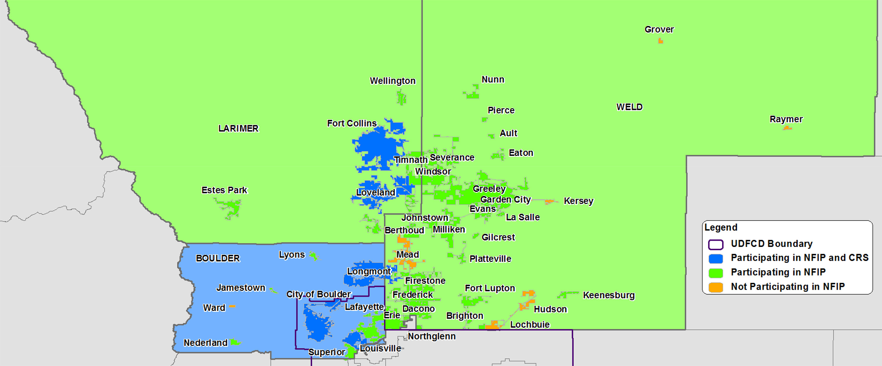
While 18 counties experienced significant damages from the September 2013 floods, the most substantial and severe damages were in Boulder, Larimer, and Weld Counties. These counties also have some of highest-rated National Flood Insurance Program (NFIP) Community Rating System (CRS) jurisdictions in Colorado. Conversely, several jurisdictions in these counties do not participate in the NFIP, providing a natural laboratory for comparison (See Figure 1).

Loss Avoidance Methodology
These floods provided a unique opportunity to evaluate the losses avoided through a nontraditional approach. The primary focus of this study was to evaluate the impacts of floodplain management through higher regulatory standards and policy actions. In addition to evaluating the impacts of floodplain regulations, this study examined a traditional mitigation project in Longmont, CO.
Traditional Mitigation Project
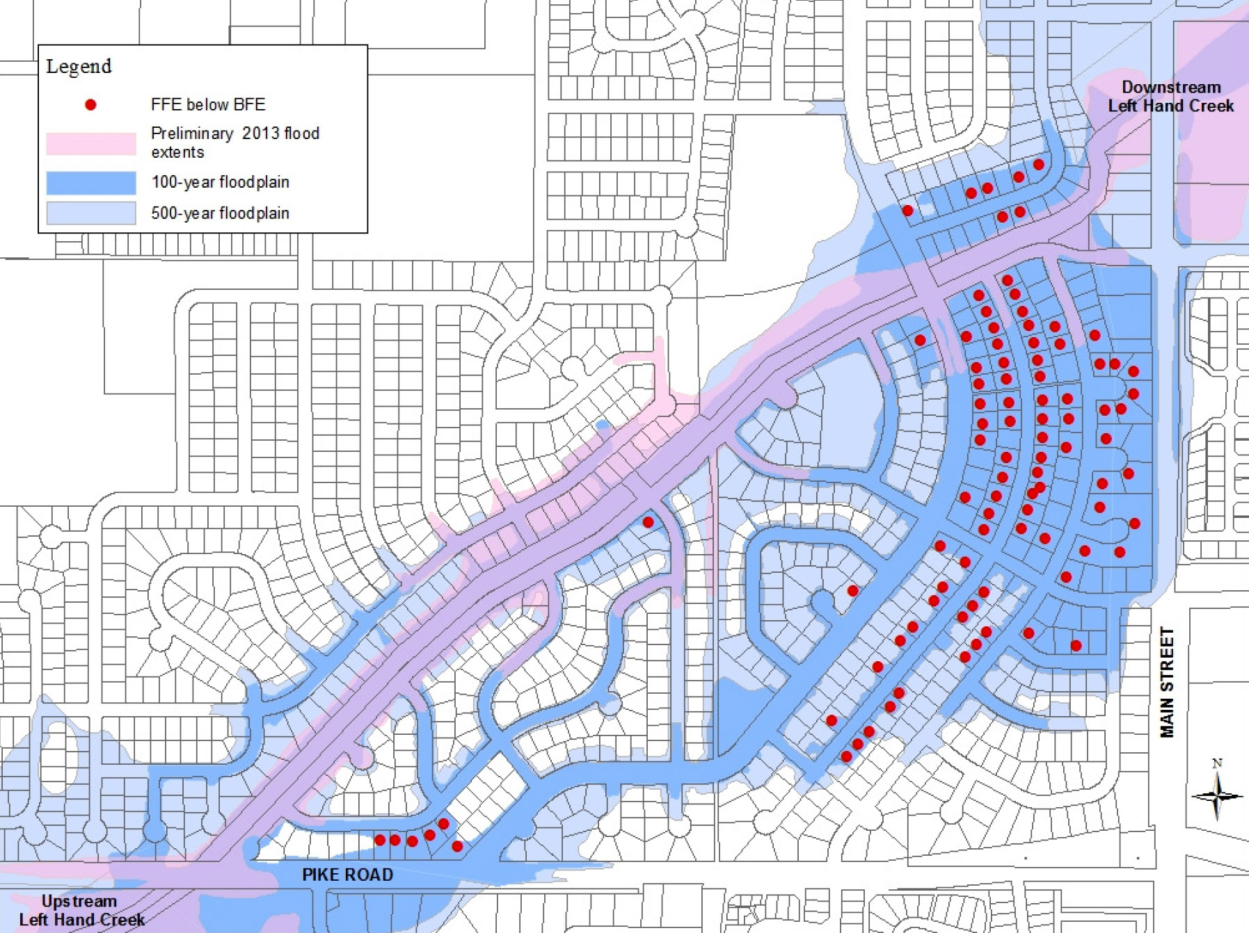
A 2010 proposed Pre-Disaster Mitigation (PDM) project for the City of Longmont (Left Hand Creek Flood Project) was awarded and completed in 2012. The mitigation project was designed to increase the flow capacity of the creek channel through a mixed-use area. The Left Hand Creek Flood Project improved the creek channel design and updated and resized two bridge culverts. The proposal identified 110 structures the flood project would remove from the Special Flood Hazard Area (SFHA) as depicted on the Flood Insurance Rate Map (FIRM) (See Figure 2).

Figure 2. Structures To Be Removed from SFHA in the Left Hand Creek Flood Project Proposal
Higher Regulatory Standards
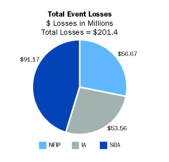
Although the CRS concepts of adopting higher regulatory standards and floodplain management principles are advocated as best practices, there is little empirical data to demonstrate the ROI for these regulatory or policy actions. The goal of this study was to quantify these benefits and demonstrate what types of regulations and policies could have the most substantial impact on reducing future damages. This was the first time FEMA was able to take advantage of existing geospatial data (such as parcels, building footprints, and floodplain data), combined with 2013 loss data from several federal programs (i.e., NFIP, FEMA Individual Assistance [IA], and Small Business Administration [SBA]) (see Figure 3) to perform a detailed analysis of the impacts at the structure level.

Figure 3. Total Event Losses for the 2013 Colorado Floods in Boulder, Larimer and Weld Counties
The study evaluated scenarios including regulating freeboard, restricting the building of residences and critical facilities in regulatory floodplains, and controlling development in erosion zones. In addition to regulations, the study investigated how the adoption of regulations over time affected losses, and how CRS scores affected NFIP claims and policies.
Return on Investment
The results of this study demonstrate that higher floodplain regulations result in a reduction in flood-related losses.
These results, in addition to traditional mitigation actions, can be used by floodplain managers and community officials to support the case for implementing higher regulatory standards for flood mitigation and protection.

