Culminating over a decade of research, “Building Codes Save: A Nationwide Study of Loss Prevention” quantifies the associated physical and economic losses from flooding, hurricane wind, and earthquakes that were avoided due to buildings being constructed according to modern, hazard-resistant building codes and standards.
View the "Building Codes Save" Report and Materials
Background
First published in 2000, the I-Codes are updated every three years and incorporate specific hazard provisions that reduce damage resulting from floods, hurricanes, and earthquakes. Those natural hazards form the focus of the study, Building Codes Save.
The study’s hypothesis is that communities with significant hazard exposure that are proactive in adopting and enforcing the I-Codes realize associated financial benefits. To measure the benefits, FEMA developed, tested, and validated a method using a progressive phased approach. The fourth and final phase is to implement the methodology nationwide and calculate the Average Annualized Losses (AAL) associated with the adoption of multi-hazard resistant building codes. The findings are intended to inform and aid proactive risk-reduction planning and decision-making by community officials.
Phases
Phase 1: Pilot Study
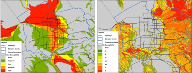
The pilot study presented the quantitative estimates of losses avoided for the seismic hazard in Salt Lake County, UT, and for both the hurricane and flood hazards in Charleston County, SC.
The seismic pilot study in Salt Lake County, Utah, used a combination of county assessor’s data and the results of a previous Hazus development effort conducted as part of the 2010 Utah ShakeOut scenario and exercise. The data received from the ShakeOut scenario was modified slightly as the study team only considered buildings constructed after 2002 which was when the 2000 International Building Code (IBC) and International Residential Code (IRC) were adopted in Salt Lake County. In addition, five occupancy types (three commercial, two residential) are included to represent the largest percentage of recently constructed buildings in Salt Lake County.
The flood pilot study conducted in Charleston, South Carolina, included data from five incorporated towns and cities. The data provided to the project team did not include many of the building attributes important for conducting the losses avoided analysis and consequently required extensive efforts and assumptions to make it usable.
The hurricane wind pilot study, also conducted in Charleston County, included data consistent with the flood pilot study. Building attribute data regarding hurricane performance were not available and had to be assumed.

| Hazard | Lessons Learned |
|---|---|
| Seismic | Many assumptions were still required to complete the pilot study. Hazus does not have a computation option for the AAL in the Advanced Engineering Building Module, making it difficult for an inexperienced user to compute an AAL. |
| Flood and Hurricane | The lack of complete building and hazard data provided the opportunity to assess whether incomplete datasets can be used to perform a Hazus analysis and successfully compute losses avoided. The project team concluded that the findings are reliable only when viewed from an aggregate point of view. |
Phase 2: Regional Study
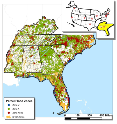
Phase 2 widened the scope of the flood pilot study to focus on all eight states in FEMA Region IV.

The hazard-specific modeled building code provisions that contributed to the losses avoided were:
- Flood: freeboard, foundation type;
- Hurricane: Wind Building Characteristics (WBC), opening protection (shutters); continuous load path, roof-deck attachment, roof cover, strength/reinforcing in masonry wall systems;
- Seismic: Model Building Type (MBT), design ground motions assigned on a site-specific basis used to determine Hazus design level.
Phase 2 identified that hundreds of millions of dollars in losses avoided resulted from the current I-Code use over the past 14 years in this part of the country covered by FEMA Region 4. The highest losses avoided were concentrated along the coastal areas and accounted for over 40 percent of the losses avoided. Specifically, Florida was the dominant state with the greatest exposure and the most avoided losses.
Phase 3: National Methodology
Phase 3’s purpose was to formalize a methodology that is being implemented in the Phase 4 nationwide study. The methodology was built on the findings of the first two phases.
- Step 1: Perform data collection and screening to identify relevant data
- Step 2: Input data into analysis tool (Hazus)
- Step 3: Adapt damage curves
- Step 4: Compute and analyze damage and economic losses and losses avoided using Hazus
- Step 5: Evaluate losses avoided findings
- Step 6: Perform quality assurance of results
| Input Loss Parameters | Hazard Damage Functions |
|---|---|
| Flood Loss Parameters Foundation type Base flood elevation freeboard | Compare pre- and post-I-code flood depths |
| Wind Building Parameters Roof opening Protection connections | Compares code-era wind speed and regional practices |
| Seismic Model Building Parameters Structure dynamics (Sd) | Compare construction quality levels assigned to pre- and post-I-Code conditions |
(Pre-I-Code damage) - (Post-I-Code adoption damage) = Losses Avoided
The losses avoided associated with new building code provisions will be computed for each hazard scenario as the difference between the results of Hazus runs with and without modern building code provisions.
Phase 4: Assessing The Losses Prevented From The National Methodology
The nationwide study is using the national methodology to develop decision-making data to incentivize communities that have not yet adopted the I-Codes. This would significantly advance FEMA’s mission to prepare, mitigate, respond, and recover from natural hazards on a whole community basis. It would also provide a clear national metric for quantifying all-hazards disaster risk reduction. The resulting quantifiable benefits could then be incorporated across technical guidance and mitigation strategies and impact many communities and stakeholders.
The ability to develop a common framework for a nationwide losses avoided study is made possible by the I-Codes. Evaluating national trends driven by local decisions affords an opportunity to evaluate perceptions regarding the effectiveness of the I-Codes and of their potential value as an emerging national standard. Comparing and scaling losses avoided study findings is intended to help accelerate the dialogue and shape perceptions towards a goal of full nationwide code adoption. Higher building code standards are a sorely needed new normal for accelerating hazard reduction and avoided losses. Continual increase to the nation’s losses avoided through disaster-resistant building codes will improve resilience to natural disasters. As more buildings are constructed in compliance with disaster-resistant codes that accrue over time, the avoided losses will increase.
Frequently Asked Questions
Were International Energy Conservation Code or other energy codes used as part of the study? Also, did FEMA evaluate avoided losses from implementation of "above-code" standards such as a “fortified home”?
Energy codes are not part of the study. The study does not address life cycle costs. Instead it looks at hazard losses. The current scope doesn't include above code. As a reference, the hazard specific slides in the August 2019 FEMA Resilience Lunch and Learn Losses Avoided Study provide examples of defining the calculations.
Will the study’s improvements to Hazus be available any time soon to other Hazus users, e.g. states for hazard mitigation projects and planning?
The Hazus team maintains a schedule for product releases and updates. FEMA’s Building Science Branch coordinates with the Hazus team and provides information to potentially use in a future release.
In November 2020, FEMA’s Hazus program released the National Risk Index which highlights the consequence and frequency risk factors for 18 natural hazards. Each natural hazard are represented in terms of Expected Annual Loss, which incorporate data from Natural Hazard Exposure, Natural Hazard Frequency and Historic Loss. In addition, geographic risk factor information such as social vulnerability and community resilience is also included. The data can be searched at the county level and by census tract.


