Challenge
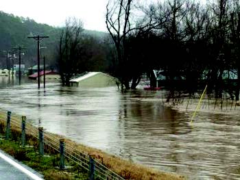
In May and June of 2015, Oklahoma experienced severe flooding in the southeastern two-thirds of the state. High watermarks (HWMs) provide valuable data for understanding recent and historical flood events. However, HWMs are perishable and must be collected soon after floodwaters recede. In addition, to effectively use the data collected, the HWMs need to be georeferenced and analyzed in a Geographic Information System (GIS).
Solution
The State of Oklahoma, in consultation with FEMA Region 6, developed processes and procedures and deployed teams to collect HWM data. FEMA Region 6 provided geospatial data analysis support for the HWM data collected.
Outcome/Results
FEMA, the U.S. Army Corps of Engineers, and the Oklahoma Water Resources Board (OWRB) Cooperating Technical Partner (CTP) worked together to document more than 980 HWM signs across several Oklahoma counties. HWM coordinates, site photographs, and field notes were collected using Mobile Information Collection Application (MICA) software and then analyzed to produce map books by watershed and stream name. An interactive map viewer, depth grids (in conjunction with Interferometric Synthetic Aperture Radar [IFSAR]), inundation maps, and project summaries by county were also produced.
Benefits
The benefits associated with HWM collection and analysis include the following:
- Informs FEMA’s Public Assistance, Floodplain Management, and Insurance team efforts
- Allows review of currently available flood hazard mapping against a recent event(s)
- Assists State of Oklahoma in assessing current flood risk
- Identifies potentially dangerous low-water crossings
- Identifies vulnerable populations
- Provides affected communities with a better understanding of recent flood events
- Provides information to refine flood risk profiles, extents, and vulnerability assessments within the state hazard mitigation plan
- Offers data points to prioritize future flood hazard mapping program investment
- Identifies mitigation activity opportunities for long-term risk reduction
- Determines event frequencies and recent rainfall amounts
Lessons Learned
Risk MAP Phases
This project involved the following Risk MAP phases:
- Discovery
- Data Development and Sharing
- Risk Awareness and Mitigation Outreach
Risk MAP Goals Advanced
The Risk MAP goals that were advanced through this project included:
- Advancing Action
- Identifying Action
- Increasing Awareness
HWM data disappears quickly. It was challenging to establish field data collection procedures, procure the necessary supplies, and train crews immediately following the flood event. To obtain the best HWM data availability it was important to begin data collection during FEMA’s response efforts. It would have been preferable to have an interagency coordination effort as part of an emergency response planning exercise prior to the flood event. The HWM data were not only useful in validating the flood hazard boundaries on existing Flood Insurance Rate Maps (FIRMS), but they were also valuable in demonstrating risk and the need for flood hazard mapping for communities without flood hazard mapping.
Resources
Oklahoma Water Resources Board