Challenge
Despite significant flood risk, roughly two-thirds of North Dakota had no FEMA flood risk data. Without data, many small cities and the rural population were left with little information to base their local floodplain management regulations and decisions.
Solution
FEMA partnered with North Dakota to provide flood risk information for the entire state. This solution included three noteworthy components:
1. A STATEWIDE BASE LEVEL ENGINEERING DATASET
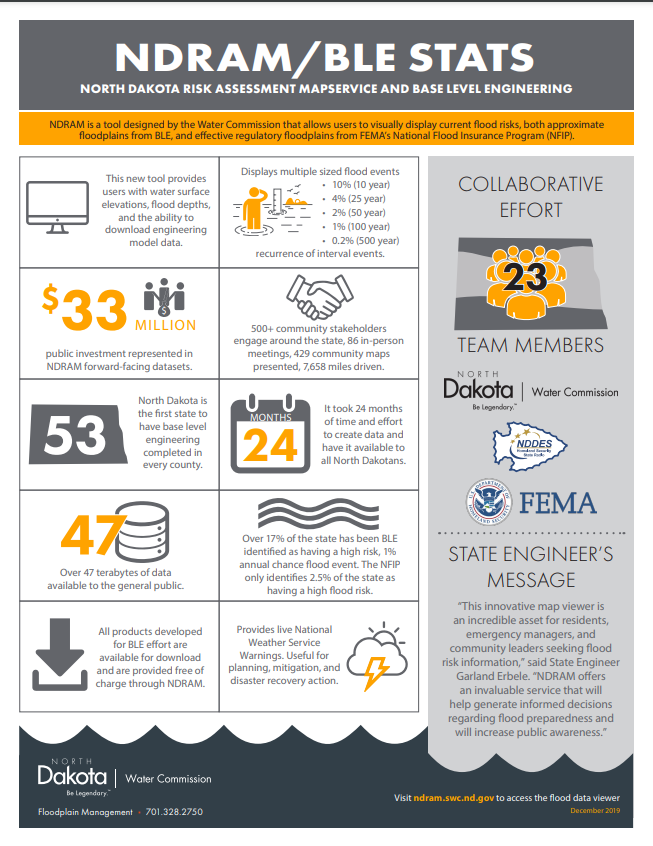
Base Level Engineering (BLE) is a cost-effective engineering approach that uses two-dimensional (2D) modeling and high-resolution terrain data to produce technically sound flood risk analyses. Local communities can use BLE to understand and plan to help reduce their hazards. It does not deliver the specificity that detailed engineering studies do. However, BLE is valuable because it can provide approximate A Zone ready floodplains, depths grids, velocity grids and water-surface elevation grids faster and for less money than a traditional study.
North Dakota provided the high-resolution terrain data component through acquiring LiDAR. FEMA funded the engineering analysis through its engineering provider. The North Dakota State Water Commission (also referred to as the State Water Commission (SWC)) conducted quality checks (QA/QC) on the modeling. This collaboration between the FEMA region and the state offices resulted in a statewide BLE dataset for floodplain management.
2. ENHANCED ENGAGEMENT AND OUTREACH
In order to generate public awareness about this flood risk information and to verify its accuracy through accounts of conditions on the ground, state and regional staff performed outreach throughout the state. Meetings were conducted with every North Dakota county at least twice. The first was introduced as a Kickoff meeting and the second as a discovery meeting. These meetings allowed the SWC to build rapport with community officials and accomplish the following:
a. Build trust between their staff and county leaders.
b. Create 53 discovery reports, one for every county in the state.
c. Verify the accuracy and credibility of the data by talking to community officials, who could describe historical conditions on the ground.
d. Determine needs, such as potential mitigation projects.
e. Create a state priority list of areas that need a traditional FEMA flood mapping study.
f. Identify specific needs dealing with levees and levee certification, such as freeboard requirements and wrap-around problems.
g. Assist FEMA in achieving its metrics by showing mapping program progress in the form of increased New, Validated or Updated Engineering (NVUE) stream miles.
3. DATA SHARING
To make the BLE data accessible, the SWC created the North Dakota Risk Assessment MapService (NDRAM). The service—holding 47 terabytes of data—provides reports, flood risk visualizations, and modeling. In-house SWC IT staff leveraged their experience with the preexisting LiDAR Dissemination MapService to create a new MapService to house the statewide BLE dataset. The results of the effort created the NDRAM platform to disseminate technical BLE deliverables and display georeferenced flood risk information in a user-friendly format.
Risk MAP Phases
This project involved the following Risk MAP phases:
- Discovery
- Data Development and Sharing
- Risk Awareness and Mitigation Outreach
- NFIP Map Changes and Impacts
- Preliminary Map Release and Mitigation
- Resilience
Risk MAP Goals Advanced
The Risk MAP goals that were advanced through this project included:
- Increased Deployment
- NVUE Initiated or Achieved
- Advancing Action
- Identifying Action
- Increasing Awareness
National Mitigation Investment Strategy Connections
GOAL 1: Show how mitigation investments reduce risk
- Recommendation 1.2 increase mitigation investment by building the capacity of communities to address their risks
GOAL 2: Coordinate mitigation investments to reduce risk
- Recommendation 2.1 Make risk information more available and easier to use
Outcome
This effort developed flood risk data for the entire state, replacing outdated information, facilitating the phasing-out of the paper-only map inventory, and providing data where there was none. This data can also be used to back up mitigation and post-disaster grant applications and bolster Hazard Mitigation Plans.
Benefit
More people in North Dakota now have access to digital, easily understandable flood risk information. Relationships between the SWC and individual counties have also been strengthened. The data has helped create a prioritized list of traditional FEMA flood mapping studies to be funded in the future.
Lessons Learned
Engagement is a huge part of this effort’s success. The technical BLE data and viewer are the foundation, but extensive outreach to this large stakeholder group was critical in achieving understanding and use.
Resources
North Dakota Risk Assessment MapService
LiDAR Dissemination MapService
Water Commission Publications: