
FEMA’s Hazus program provides software, data, methods, and guidance for estimating risk from natural hazards. Hazus can estimate building damages, economic losses, displaced households, casualties, debris generation and more resulting from a natural hazard event, and can be used in all phases of emergency management.
Featured Publication: New FEMA Tsunami Loss Study
FEMA has led the first national assessment of its kind to quantify and compare tsunami risk across most U.S. coastal communities in the United States. The study estimates that buildings and residents across the U.S. country could face more than $1 billion in potential average annualized losses.
With more knowledge of their tsunami risk, communities are empowered to identify and implement effective strategies to evacuate residents and reduce the risk to buildings in the tsunami hazard zone.
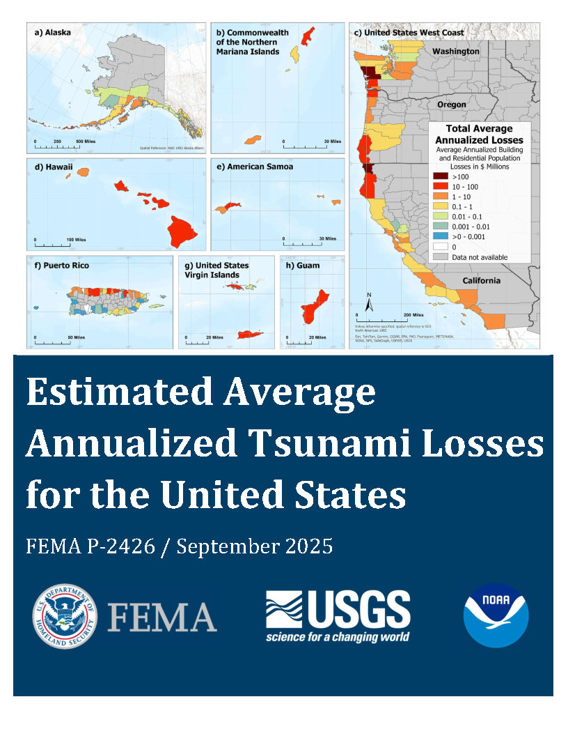
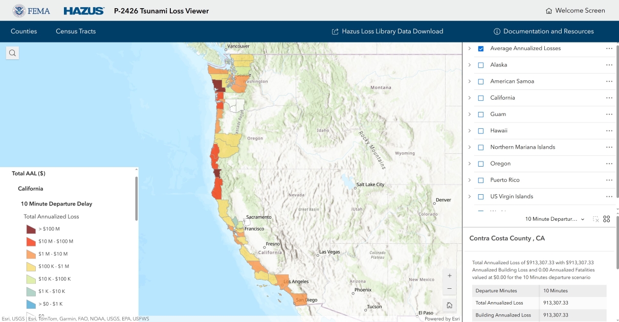
View the tsunami study results in the Tsunami Loss Viewer, an interactive version of the map. Users can explore annualized or scenario-level tsunami losses for buildings and/or population at the county and Census tract levels.
Explore the following resources to learn more about the study:
- FEMA P-2426 Report: Read the Estimated Average Annualized Tsunami Losses for the United States report.
- Tsunami Study Overview: Read the Tsunami Study Overview for a summary of the study and ideas on how to use its results and products in your community.
- Data Release: Explore the Estimated Average Annualized Building and Population Losses from Earthquake-generated Tsunamis in the United States data release.
What is Hazus?
The Hazus software is distributed as a GIS-based application with inventory databases for every state and territory in the nation and is built on Esri’s ArcGIS Pro desktop software. Leveraging ArcGIS, Hazus simplifies workflows and improves the efficiency of risk assessment and mapping analysis for users.
The Hazus program partners with other federal agencies, research institutions, and regional planning authorities to ensure Hazus incorporates the latest scientific and technological approaches. Each Hazus model uses inventory information (buildings, infrastructure, and population), hazard extent and intensity data, and damage functions to estimate the impacts of disasters. The program provides baseline datasets for these inputs so that any community can quantify risk, regardless of data availability. However, users are encouraged to modify Hazus model inputs to include more accurate local information.
Download Hazus
Download the latest version of Hazus and state databases from the FEMA Map Service Center.
Read the Release Notes to learn more about the latest version of Hazus.
Hazus 7.1 Release
Hazus 7.1 is now available for download on the FEMA Map Service Center.
Hazus 7.0 and 7.1 are the first of several updates that will bring users the key features of Hazus with the enhanced capabilities of ArcGIS Pro. To understand what’s new, view the Hazus Side by Side Comparison and the Hazus in ArcGIS Pro Latest Improvements Guide.
Technical manuals and supporting documentation for the latest Hazus release as well as previous
Hazus User Guides and training videos are a great way to learn at the individual level.
Who Should Use Hazus?
FEMA’s Hazus program supports data-driven decision making for mitigation, preparedness, response, and recovery. Hazus can be used to evaluate mitigation actions, and states, local, tribal and territorial entities are encouraged to use Hazus to complete the risk assessment component of their hazard mitigation planning. Emergency managers, planners, and researchers can use Hazus to map the potential impacts of catastrophic events, communicate risk to communities, and is used during real-time disaster response to estimate the impacts of incoming storms.
Hazus Loss Library
The Hazus Loss Library is a free online collection of Hazus-generated risk assessments that can support all phases of emergency management. Search the library to find Hazus flood, hurricane, earthquake and tsunami products (Release 6.1 for both) with Hazus results downloadable in spatial, tabular, and report formats.
View the factsheet for more information, or visit the Hazus Loss Library to find risk information available for your community.
Contact the Hazus Team
Contact us at the Hazus Helpdesk by email anytime for Hazus technical assistance, data needs, or methodology questions.
Sign up to receive updates about the Hazus Program, including our latest projects and links to our quarterly newsletters and webinars, training, and conferences.