

Mitigation is protecting what you value—people, your home, your belongings – from risk. FEMA encourages community partners to identify, assess, and reduce risk through hazard mitigation planning and implementation.
Every year in the United States, flooding destroys thousands of homes, causes billions of dollars in damages and tragically claims lives. Flooding is the most common natural disaster in Pennsylvania. We all have a role to play in helping to make Pennsylvania communities safer and more resistant to disaster. Identifying your community’s flood hazards and then acting to reduce those risks will result in a stronger, more resilient community.
Flood Mapping in Pennsylvania
Understanding where it will flood and which parts of your community have the highest flood risk, is one of the first steps in taking action to mitigate risk.
- Pennsylvania’s Flood Risk Tool is a searchable map with detailed information about flood risk in PA.
- FEMA’s Map Service Center is the official repository of all flood maps. For questions, call 1-877-FEMA MAP (1-877-336-2627) or email a FEMA map specialist.
Susquehanna River Flood Map Updates
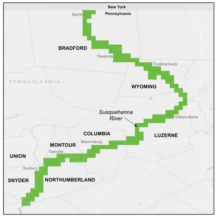
In early September 2011, Tropical Storm Lee dropped record-breaking rain on the Susquehanna River region of Pennsylvania, producing widespread and historic flooding not seen since Hurricane Agnes in 1972. In response, FEMA and the U.S. Army Corps of Engineers (USACE), began a re-studying flood risk in the Susquehanna River Basin.
As a result of the update, FEMA is releasing new Flood Insurance Studies (FIS) and Flood Insurance Rate Maps (FIRMs) for the following counties along the Susquehanna River: Snyder, Northumberland, Union, Montour, Columbia, Luzerne, Wyoming, and Bradford. In total, FEMA is producing updated flood maps for approximately 181 miles of the Susquehanna River.
Susquehanna River – Study Resources
It is important for residents, property owners, and community members affected by the Susquehanna River flood map updates to be informed. Local officials or community partners can use the resources below to support outreach efforts.
Susquehanna River Study Fact Sheet
This fact sheet details the flood mapping updates, study results, timeline of events, next steps for communities, and flood insurance impacts.
Levee Factsheets
There are many levees along the Susquehanna River throughout the study area. Each levee has different characteristics and provides varying levels of risk reduction.
These fact sheets explain flood risk, how FEMA is mapping the levees, impacts to insurance, and estimates of people and infrastructure at risk behind the levees.
Community Flood Risk Dashboards
These community dashboards provide a snapshot of a community’s flood risk statistics. They include the number of properties newly identified within a high-risk flood zone, number of National Flood Insurance Program (NFIP) policies in force, and more.
Share these dashboards with community stakeholders, such as property and business owners, to help increase their understanding of local flood risk and the NFIP.
Susquehanna River Flood Map Viewer
This interactive map highlights changes to the flood level, flood depth, and extent of flooding from the Susquehanna River as a result of the updated study. The information shown is draft, but it provides valuable insight into the flood risk changes communities may face.
You can search by address, community, or location.

Communication Tools
These resources contain general information on flood risk, flood insurance, and the value of mitigation. Use them to promote flood risk awareness and encourage stakeholders to take action to reduce their risk.
FEMA Flood Risk Communication Toolkit for Community Officials
- Start Guide - Introduces the Toolkit’s components and provides tips for discussing complex risk topics in a meaningful way.
- Communication Plan Guide - Developing a communication plan to share information about natural hazards is a strategic step that community officials can take to protect the people and things most valued in their community. This guide helps community officials organize messages and desired outcomes by laying out a seven-step process.
- Designing Effective Public Meetings Guide - Shares information on how to design more effective meetings, from planning to setting clear goals and objectives, to the steps to take when the meeting is over. Includes tips for conducting early, effective, and comprehensive engagement.
- Social Media Guide - Social media is an important tactic to consider when designing your communication plan. Local governments have a front row seat in their community and are ideally positioned to create timely, pertinent posts that spur clicks, likes, comments, shares, and views. This guide includes how, when, and why to consider using social media, as well as best practices.
- Flood Risk Communication videos - This video series visually communicates the objectives of updating the community’s flood risk data and maps and includes stories from community members.
- Flood Risk Communication Video Guide - This guide includes links to the videos and suggestions on how and when to use them to communicate on a variety of topics such as changing flood risk, coastal flood risk, the process of updating flood risk data and maps, community support, and mitigation.
- Appendix - The Appendix includes a collection of community engagement examples organized by category.
Mitigation Brochures
Flood Insurance
Anywhere it can rain, it can flood—just one inch of flood water can cause $25,000 in damage. Flood insurance is encouraged whether or not a property is in a high-risk flood area, and rates will be lower in moderate and low-risk areas.
- National Flood Insurance Program - Visit floodsmart.gov to learn more about why flood insurance is important and how you can buy it.
- Pennsylvania Insurance Department – The PA Insurance Department has helpful information about purchasing flood coverage to protect your property.