Hazus is a nationally standardized risk modeling methodology. It is distributed as free GIS-based desktop software with a collection of inventory databases for every U.S. state and territory. Hazus identifies areas with high risk for natural hazards and estimates physical, economic, and social impacts of earthquakes, hurricanes, floods, and tsunamis. The Hazus Program, managed by FEMA’s Natural Hazards Risk Assessment Program, partners with other federal agencies, research institutions, and regional planning authorities to ensure Hazus resources incorporate the latest scientific and technological approaches and meet the needs of the emergency management community.
Hazus is used for mitigation, recovery, preparedness, and response. Mitigation planners, GIS specialists, and emergency managers use Hazus to determine potential losses from disasters and to identify the most effective mitigation actions for minimizing those losses. Hazus supports the risk assessment requirement in the mitigation planning process. Response planners use Hazus to map potential impacts from catastrophic events and identify effective strategies for response and preparedness. Hazus is also used during real-time response efforts to estimate impacts from incoming storms or ongoing earthquake sequences.
Hazus can quantify and map risk information such as:
- Physical damage to residential and commercial buildings, schools, critical facilities and infrastructure.
- Economic loss, including lost jobs, business interruptions, and repair and reconstruction costs.
- Social impacts, including estimates of displaced households, shelter requirements, and populations exposed to floods, earthquakes, hurricanes and tsunamis.
- Cost-effectiveness of common mitigation strategies, such as elevating structures in a floodplain or retrofitting unreinforced masonry buildings.
Hazus International
International users are free to download Hazus software. However, adjusting hazard parameters and creating data inventories for areas outside the U.S. may require significant effort. Please reach out to the Hazus Team with questions or for additional resources.
Sign up to receive updates about the Hazus Program, including our latest projects and links to our quarterly newsletters and webinars, training, and conferences.
Models and Analysis
The Hazus program maintains models for estimating the risk of damage from earthquakes, floods, hurricanes, and tsunamis. Each Hazus model uses inventory information (buildings, infrastructure, and population), hazard extent and intensity data, and damage functions to estimate the impacts of disasters. Estimated impacts vary by model, but include building damages, economic losses, displaced households, casualties, debris, and the loss of function for essential facilities. The Hazus program provides default datasets for each of these inputs so that any community can quantify risk, regardless of data availability. However, users can modify all Hazus model inputs to include more accurate local information.
Check out our Technical Manuals and User Guidance to learn more about each Hazus model.
Hazus Earthquake Model
The Hazus earthquake model evaluates the probability of damage to buildings and infrastructure according to ground shaking data from the U.S. Geological Survey (USGS) ShakeMap website. Robust analyses should also consider ground failure data from state geological surveys.
Hazus Tsunami Model
The Hazus tsunami model estimates economic loss and physical damage to buildings due to the depth and force of tsunami waves in five high-risk states (California, Washington, Oregon, Hawaii and Alaska) as well as U.S. territories in the Pacific and Caribbean. Calculations can be combined with earthquake loss estimations to quantify additive impacts from near-source tsunami events.
Hazus Flood Model
The Hazus flood model calculates physical damage and economic loss due to coastal and/or riverine inundation. Losses are calculated using functions that relate the depth and type of flooding to the degree of damage for various categories of buildings. Visit the Hazus MSC page to find a simplified, open source version of the Hazus Flood model called the Flood Assessment Structure Tool (FAST).
Hazus Hurricane Model
The Hazus hurricane model estimates physical and economic damage to buildings due to wind and windborne debris. Wind hazard data are generated at the census tract level. The model considers peak gusts, terrain roughness and tree coverage data for incoming hurricanes, historic storms, or probabilistic hazards. This process can be combined with an internal storm surge model or user-supplied surge data to estimate the damage to buildings caused by coastal flooding driven onshore by hurricane winds.
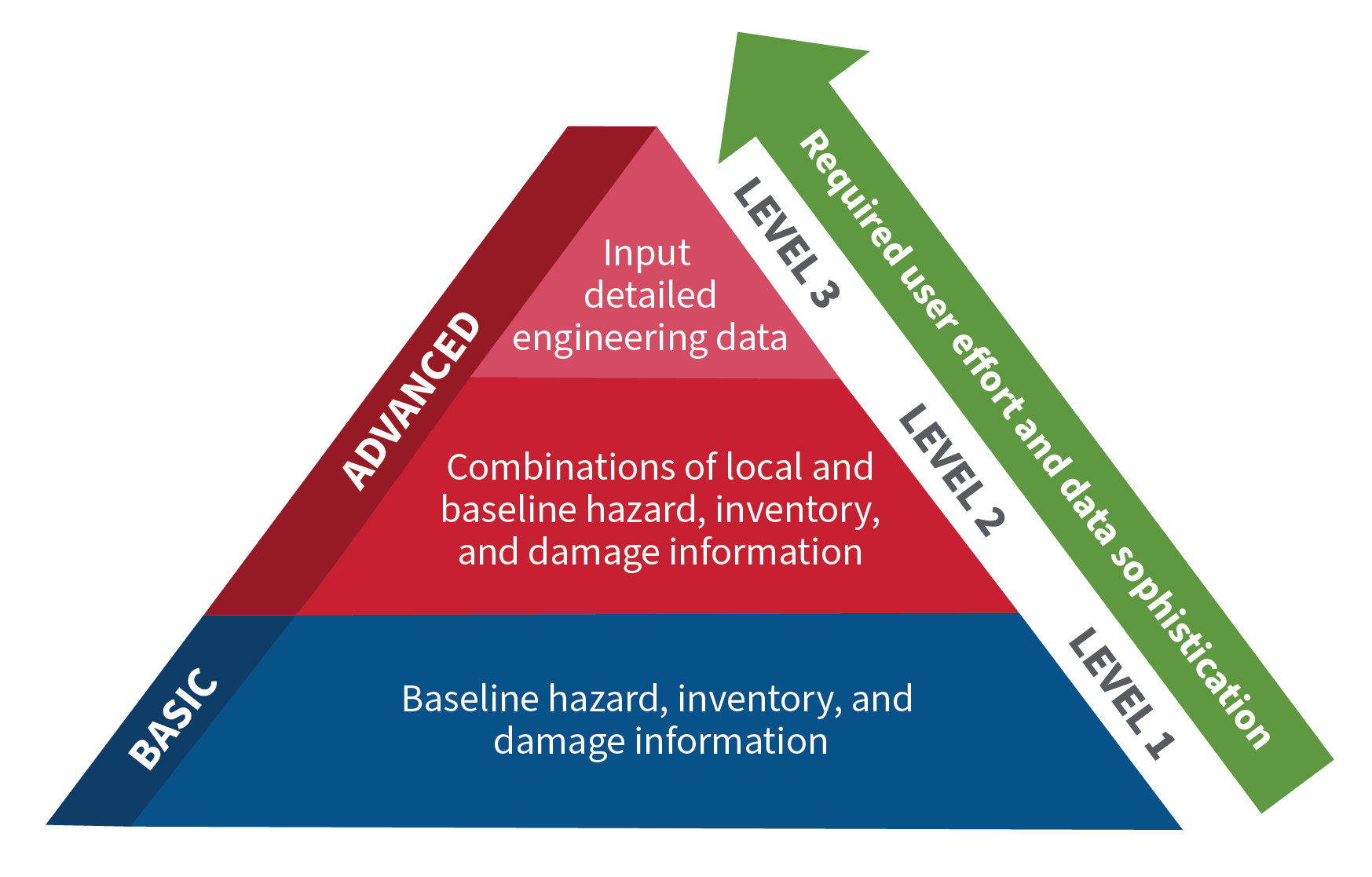
Hazus Analysis Levels
Hazus risk analyses are categorized as Basic or Advanced, depending on the level of effort and expertise required by the user. Advanced Hazus analyses incorporate more detailed local data about a community’s population and assets to generate more accurate and applicable loss estimates.
Basic
A Basic (“Level 1”) Hazus analysis produces initial estimates of earthquake, flood, tsunami, or hurricane wind losses. Basic results are based on the generalized national databases and best available information included in Hazus software. Users can learn how to run a basic Hazus analysis by watching FEMA’s Hazus training videos on YouTube.
Advanced
An Advanced (“Level 2” and “Level 3”) Hazus analysis produces more accurate loss estimates by including information on local hazard conditions and replacing generalized national data with more accurate local inventories of buildings, essential facilities, and infrastructure.