

WASHINGTON -- On Monday July 11, FEMA Administrator Deanne Criswell delivered keynote remarks at the 2022 Environmental Systems Research Institute (Esri) User Conference in San Diego, California.
At the event, she discussed how geospatial and predictive forecasting tools help to make communities more resilient in the face of climate change and support FEMA’s readiness to respond to disasters.
“We have to understand the threats that we have faced in the past, but we have to be better prepared for the threats that we are going to face in the future, because our landscape is changing,” said Administrator Criswell. “We have to start to embrace the fact that our world is changing around us, and we have to be able to use this type of technology to help us plan for the future. This type of predictive data ... has never been more important to help our emergency management community get ahead of the threats that we are going to face in the future.”
The Administrator’s remarks as delivered can be found below. Following her remarks, she participated in a sit-down conversation with Esri President and Founder Jack Dangermond.
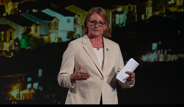
FEMA Administrator Deanne Criswell delivers remarks during the Esri User Conference July 11.
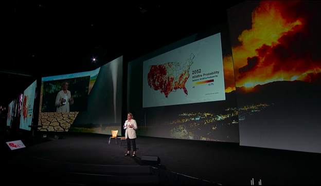
FEMA Administrator Deanne Criswell discusses wildlife probability at the at the Esri User Conference July 11.

FEMA Administrator Deanne Criswell speaks with Esri President and Founder Jack Dangermond.
Tackling Climate Change by Building Community Resilience
Administrator Criswell’s remarks as transcribed
Let me just start by saying the nation needs you. And for those of you who are watching from around the world, your nations need you as well.
I’m Deanne Criswell. I’m the Administrator of the Federal Emergency Management Agency. What you just saw is what we call our anthem. This is our visual depiction of our strategic plan that is helping us achieve our vision of helping us become the FEMA that our nation needs and deserves.
And what I want to talk to all of you about today, is how important your role is in helping us achieve that vision of helping us help people before, during and after disasters. Before I start, I would just like to thank Jack and this entire ESRI team, the outstanding work that went into making this event possible. I don’t know about all of you, but I have been inspired. I have been motivated and I have all kinds of ideas that I know when I go back, my team is going to say stop sending her to these things, because there’s so many things that I’ve learned today that are just going to help us do our jobs better.
And my goal today is to empower all of you, empower you to see yourself as part of that mission of helping us build a more prepared and more resilient nation. Because the truth is, we need your help now, more than we ever have.
So, what does our threat landscape look like? Well, I can tell you from my experiences, just in the last year alone, my time in this position, that no one is immune. All of you, in all of your communities, are experiencing disasters, natural hazard threats like we’ve never seen before.
When I think about the west coast, I think about wildfires. I think about how we no longer have a wildfire season. We have a year-long wildfire threat. Just earlier this year, New Mexico had their largest wildfire in their history. In December of last year, we had a wildfire that ripped through a suburban area of Boulder, Colorado, destroying over 1,000 homes in just a matter of hours. When I think about the Midwest, and I think about tornadoes. I think about a tornado that went through Mayfield, Kentucky. The longest tornado on record, happening in December. We normally think about tornadoes happening in the spring or the summer, not in December.
When I think about the tropics, and I think about tropical storms, we can just look back to last summer -- Hurricane Ida. We’re seeing more and more major hurricanes than we ever have before. Category 4, Category 5. Hurricane Ida, Category 4 hurricane. Made landfall -- stayed a Category 4 hurricane for several hours. Unheard of. When they make landfall, they usually dissipate. Not Ida. But she wasn’t done yet. She then traveled across nine states and finished her path of destruction, on the east coast. So that brings me to floods and flash flooding. New York City had a record rainfall amount from this post tropical system. A record that they broke that was set just two weeks before.
And then I think about heat. I think about heat domes that we’re seeing in the Pacific Northwest. You’ve heard a lot today about these types of threats that are going on. In fact, I read an article just the other day, that scientists believe that they can now directly link these heat domes are a direct result of climate change. And if you didn’t know, heat-related deaths are the no. 1 killer in America from natural hazards.
No one in this room is immune. The disasters that we are seeing, they’re increasing. They’re growing.
So when I look at this map, right here. This is a representation of all of the major disaster declarations FEMA has given since the year 2000. You can see areas that are in darker red, which means that they are getting repetitive disasters year after year.
But this is just those that got a major disaster declaration. This does not include all of those other events that just don’t rise to that level. Events that are still impacting communities each and every day.
It’s history. History is important. We have to understand the threats that we have faced in the past, but we have to be better prepared for the threats that we are going to face in the future, because our landscape is changing.
We have another map here that talks about the potential wildfire probability through the year 2052 -- showing increased risk across the nation in areas that haven’t traditionally experienced this type of wildfire risk. We also earlier today, some of the work that’s coming out of the President’s Climate Office, that’s showing other future risk. We have to start to embrace the fact that our world is changing around us, and we have to be able to use this type of technology to help us plan for the future. This type of predictive data geospatial science has never been more important to help our emergency management community get ahead of the threats that we are going to face in the future. Because right now, today and in the future, we are looking to data more than we ever have to help drive our decisions and our ability to help people.
So where does this information come from? Who’s behind this information? I learned a lot today about where a lot of this information is coming from, and all of the people that are behind creating all these amazing tools. I’m going to give you an example on one of our tools and how we use this information to help drive our decision making to help drive how we direct resources to help people. This right here is our National Risk Index. You can find this on fema.gov, and this gives us information about different risks that receive, those that I just talked about, and it combines it with social vulnerability, with community resilience, and it gives us a 30,000-foot view of really what the risk really is across our nation. This is powerful. This is such a powerful tool for us to use for emergency managers to be able to go in here and better understand the risks and their communities, so they can help develop their investments to help reduce the impacts of these risks. We will not be able to keep up with the response and the recovery cycle if these threats continue to grow. We need information like this to help us get ahead of it and reduce those impacts.
The individuals can use this risk index as well. We have seen through the COVID-19 pandemic a number of people who have moved across the country. They’re living in areas that they haven’t lived in before. They’re living with risk that they may have never experienced in the past. Tools like this, individuals can now go in, tools that we saw earlier today, and learn what their risk is in their communities so they can figure out how to plan and prepare to protect their families better.
So let’s get a little bit deeper in this. How do we use this information? Well, I’m going to start by having you look at the imagery behind me, behind all of these screens here. I talked a little bit ago, about Mayfield, Kentucky. The tornado that went through in December of last year. This is the imagery from that tornado. This is the imagery from the destruction that that tornado caused. So why is this so important? Well, this imagery is important because the sooner we can get it, and in this case, getting this kind of fidelity, this kind of eyes on without having to spend people in the field, within hours, within days of an incident happening, directly informed my recommendation to the President of the United States to say this needs to be a major disaster declaration. In the past, we would have sent people in the field. We would have walked around neighborhoods for days or even weeks to come up with that determination. But by using imagery that helps us make those decisions sooner so we can get people on the ground. Myself and my team, we were on the ground within 48 hours of this tornado making landfall.
Now we go a little deeper. We look at this image right here behind me. This now takes that path of the tornado, and it overlays it on top of that national risk index. We can now look at our neighborhoods that are the most vulnerable in society in general and see who has been impacted by this disaster, by this tornado. We can pinpoint those neighborhoods, instantly almost, and direct our resources to go in there, instead of trying to figure out again days or weeks of where the damage is. We can use this kind of information, focus those resources, get them to those neighborhoods that we know are going to need it most, especially those communities that are most vulnerable.
We’ll take it a step further. We will also add our applicant registration data. So when there’s a major disaster declaration, an individual can call FEMA, they can go online and they can ask for help. We take that information and lay it on top of here and I can see who has asked for help. But more importantly, I can see you hasn’t asked for help. I can see those communities that are the most vulnerable and I can see whether or not they have registered for assistance. And if they haven’t, I can take my people, our resources to them. Because in the end, it is all about people. It is people first.
This image is an example of our disaster survivor Assistance teams, one of our most powerful resources that we have. They are the face of FEMA immediately after a disaster happens, and with the type of information and the type of data that I just talked about, I can direct them to the street level of where to go help people. They go down with their iPads. They register them for assistance right in their front yard, and many of them will have financial assistance in their bank accounts within a few days. Powerful. Really helps us get to people. Helps us bring our services to the people, instead of making them figure out how to navigate our level of bureaucracy.
But we cannot do this alone. This is all about partnerships. This is about mapping common ground. One of the strengths of the emergency management community is partnerships. We know who to bring together to make sure we’re having the right conversations. Our emergency management community, they do not have to be the subject matter experts in what we’re trying to solve. They know though, who is, and they know how to bring them together and have those conversations. An example of this is our NRCC -- our National Response Coordination Center. This is where we bring our federal family together at FEMA headquarters -- our nonprofit partners, our NGOs, sometimes our private sector, and we sit side by side and we share information. We work together and collaboratively to solve the tough problems that we are being faced with.
But as you can see from the threats that we are facing this person-to-person relationship going into the future is not going to be enough. We have to have digital handshakes. We have to have the ability to share information digitally, quickly, so we can make quicker decisions to help people. Our Geospatial Resource Center is a great example of how we are doing this digitally. This is our digital NRCC. This is where all of our different federal family, our private sector, our NGOs are inputting their data to help us solve the tough, complex challenges that we are facing today.
But we don’t just do this during response. We use this portal, this hub, before, during and after disasters. So, before disasters, we partner with agencies like NOAA, with USGS, with NASA. They give us predictive information. They give us modeling, so we’re not only solving our problems based on historical data, but we’re looking to the future, we’re looking to what those trends are going to be to help guide our local emergency managers, our state emergency managers and how they can better invest their money to reduce the impacts that we’re seeing from these disasters. We have to be able to use this information before so we can build a stronger, more resilient nation.
But when we do have to respond, I think you heard me say in the video, time is our most precious commodity. We have to have information quickly, so we can save lives. We gather information from our partners like the American Red Cross and our local first responders. They give us valuable information to help us better understand the impacts that this disaster is having. We use things like remote sensing to help us better identify where people might be. A really great example of this is the tragic events that happened in June of last year, just over a year ago in Miami, Florida, with the Surfside condo collapse. Our urban search and rescue teams, they used remote sensing to help direct and target where they were going to do their search efforts. When minutes if not seconds, were going to make a difference. It was this type of technology that helps focus our efforts so precisely that we can do the most good for the most people.
But then after, we want to build more resilience. We want our communities to come out of this stronger. So, we partner with companies, partners like the Army Corps of Engineers the Department of Transportation, or local public works departments. We work with them as we are trying to rebuild these communities, as we are helping them repair their infrastructure. So, we can repair it better and more resilient, so they can withstand the impacts of these future threats that we are going to face.
So, I have a call to action for all of you. Right now, your nation needs you more than it ever has. As I said, nobody is immune. I bet many of you in this room have experienced some type of natural disaster, natural weather event. So, what I need you to do is a few things. I need your ideas. I need your creativity. I need your passion. Everything that we heard this morning is so inspiring. And it’s that that type of creativity and passion that needs to continue, so we can continue to get better at what we’re doing. I need you to connect and grow with each other in this room. This is such an amazing opportunity to make new relationships, learn new things, get ideas, go back to your agencies and help them see how they can do things better. I need you to develop and continue to push to develop innovative tools. So much of what we saw today – so much creativity and innovation out there. It’s only going to continue to get better and make the biggest difference in people’s lives.
This room is full of the brightest minds that are out there. If there is anybody that can help us solve these types of tough problems, it’s everybody here in this room. So, I ask you this, keep pushing the boundaries, keep innovating and creating. So we can save the most lives, we can protect the most property and we can create sustainable communities for generations to come, for our children, for our grandchildren to thrive in.
I will leave you with this: Remember, from challenge comes change -- so let’s begin.