

Not only is flooding one of the most common and costly disasters, flood risk can also change over time because of new building and development, weather patterns and other factors. Although the frequency or severity of impacts cannot be changed, FEMA is working with federal, state, tribal and local partners across the nation to identify flood risk and promote informed planning and development practices to help reduce that risk through the Risk Mapping, Assessment and Planning (Risk MAP) program.
What Is the Risk MAP Process?
FEMA is responsible for mapping our country’s flood risk. The agency and its partners do this by making Flood Insurance Rate Maps, or flood maps. Risk Mapping, Assessment and Planning, Risk MAP, is the process used to make these maps. However, it creates much more than flood maps. It leads to more datasets, hazard mitigation analysis and communication tools. Each supports communities as they work to be resilient.
The fact sheets below explain the Risk MAP process in simple language and detail how FEMA, communities, and residents can collaborate throughout and after the flood mapping process.
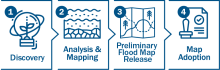
Phase 1: Discovery
Phase 2: Analysis & Mapping
Phase 3: Preliminary Flood Map Release
Phase 4: Map Adoption
What Does Risk MAP Mean For You?
While FEMA is responsible for the overall administration of the Risk MAP program, reducing risk to flooding and hazards is not a responsibility solely on the shoulders of one organization; everyone has a role to play. Whether you are an engineer performing a flood risk analysis, a state planner designing and implementing a hazard mitigation plan, or a well-informed homeowner who has purchased flood insurance, empowering individuals, organizations and communities to take proactive steps to reducing flood risk is an essential piece of Risk MAP.
Learn more about what Risk MAP means for you.
Using Risk MAP to Plan and Take Action
Risk MAP supports community resilience by providing data, building partnerships, and supporting long-term hazard mitigation planning. In particular, Risk MAP’s Flood Risk Products work alongside regulatory products to provide flood risk information and support your community’s overall floodplain management and hazard mitigation strategies.
The Flood Risk Products and datasets present information that can enhance hazard mitigation planning activities, especially the risk and vulnerability assessment portion of a hazard mitigation plan, and the development of risk-based mitigation strategies. Flood Risk Products can also help guide land use and development decisions and help you take mitigation action by highlighting areas of highest risk, areas in need of mitigation, and areas of floodplain change.
Risk MAP Products
Risk MAP vs. Regulatory Products
Risk MAP Guidelines & Standards
Risk MAP Projects
Interactive Progress Map
View the interactive map to see if any currently funded projects are in progress in your community, or contact your local floodplain administrator (often an official in the zoning or planning department).
Story Maps
Explore interactive story maps that help explain the Risk MAP process, coastal flood risk, use of FEMA mapping data, mitigation planning, and other programs.
Risk MAP Project Lifecycle
Follow the different steps that can be involved across the lifecycle for flood risk products.
Success Stories
Read stories that provide examples of Risk MAP successes at different stages in the process.
Levees and Coastal Flood Risk
Living with Levees
To help understand the realities of levee risk, FEMA provides community outreach tools and construction guidelines related to levee risk.
Coastal Resilience
FEMA is working with local community officials to produce additional data and hazard mitigation tools to enable more strategic emergency preparedness and mitigation planning in coastal communities.
Additional Resources
Hazard Mitigation Planning
Plan to minimize the impact of disasters.
FloodSmart.gov
Learn how to get flood insurance.
Flood Map Service Center (MSC)
Understand your flood risk and view your flood maps.
Ready.gov
Make a plan and be ready for disaster.