

Many communities in Nebraska are small and rural. Agriculture makes up much of the state’s economy. Many crop and livestock farms are located within the floodplain; a normal rainfall event can greatly affect these farms and the state economy. The Nebraska Department of Natural Resources (NeDNR) used the National Risk Index to analyze riverine flood risk and train local officials on the interactive tool. The Risk Index provided localized data and maps that helped communities understand more about their local flood risk so they could take action to reduce it.
Challenge
- The NeDNR develops the Nebraska Flood Hazard Mitigation Plan. It describes flood risk across the state, as well as how communities can reduce their risk. NeDNR needed public data to show local officials their risk and help with public outreach.
- Local officials in Nebraska often represent small, rural communities with limited resources. They often wear multiple hats. Therefore, it is important that NeDNR provides them with accessible training and tools to support their floodplain management efforts.
- Agriculture is the backbone of the state’s economy. Riverine flooding can affect croplands and livestock farmers. NeDNR is working to teach local communities about their riverine flood risk. Drought is a main hazard concern in the state; it can be hard to move focus, so the public sees that flooding is a risk too.
- NeDNR works closely with the Nebraska Emergency Management Agency (NEMA). They have a joint application and review process for mitigation projects and help their communities develop the right projects to reduce risk. Helping communities know their risk pushes them to submit stronger project proposals to get mitigation funding.
Solution
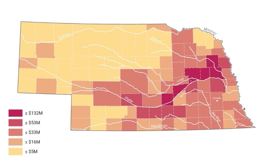
- NeDNR used the National Risk Index to analyze the annualized frequency, Expected Annual Loss, and exposure for Riverine Flooding in its flood hazard mitigation plan. The Risk Index broke down Riverine Flooding hazard exposure by asset type, which includes agricultural assets. This was the first time the plan had this information for the state’s agricultural assets. Now, NeDNR can use this to show how riverine flooding is a risk to their economy.
- The Risk Index is a public tool; NeDNR started to train local officials on making reports, analyzing multiple hazards and creating maps with the Risk Index. It gives Nebraska’s community officials an interactive tool they can use with NeDNR’s Floodplain Management Interactive Map to understand and visualize their community’s risk.
- When NeDNR and NEMA help local communities with mitigation project proposals, they can use the Risk Index to understand the riverine flood risk in each area. This helps them work with communities to apply for funding to address riverine flooding where it is needed most. When they apply for funding, the Risk Index data can be used to help demonstrate the project need.
Graphic
Key Takeaways
- The FEMA National Risk Index is a public, visual tool. The Risk Index is an online platform that is user friendly. It makes it easy for local officials to understand their risk and fill data gaps. The tool provides maps and reports that can help NeDNR with public outreach to raise awareness of hazard risk.
- Understanding risk is the first step toward reducing risk. The Risk Index gives Nebraska’s communities a starting point to assess their riverine flood risk. It’s important for communities to understand their risk so they can then choose projects to effectively reduce risk. This can help improve their chances of getting funding for their projects.
- The FEMA National Risk Index helps communities protect what matters most. The Risk Index gave Nebraska’s communities a breakdown of risk for different types of assets. This helps the state communicate exactly how riverine flooding can affect a community. Knowing this will help those communities take steps to protect their residents and local economy.